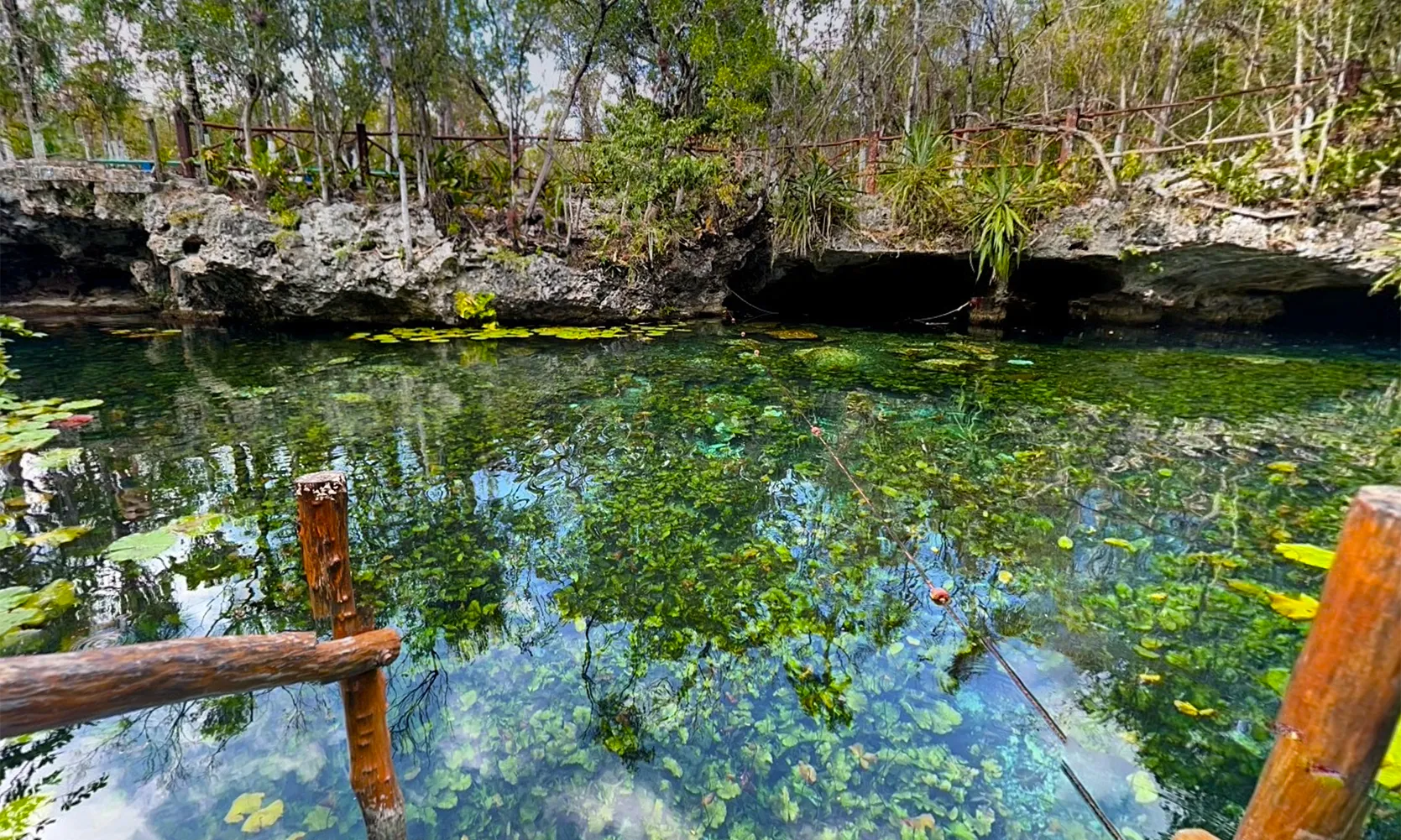
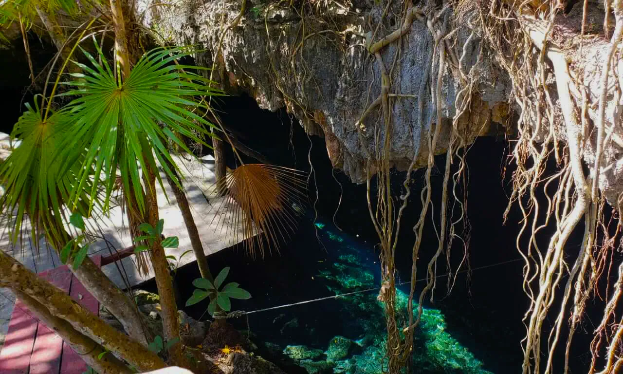
Nicte Ha Cenote is another stunning cenote in the pleiad of the Dos Ojos cave system cenotes. The entrance to this famous cenote is approximately 48 km south of Playa del Carmen. A 1 km dirt road leads from the highway to the cenote and parking.
The name “Nicte Ha” means “water flower.” It originated from the nice lily flowers growing inside the cenote's open water. Behind the name, a love story marred by tragedy explains the existence of a beautiful white flower in the cenote.
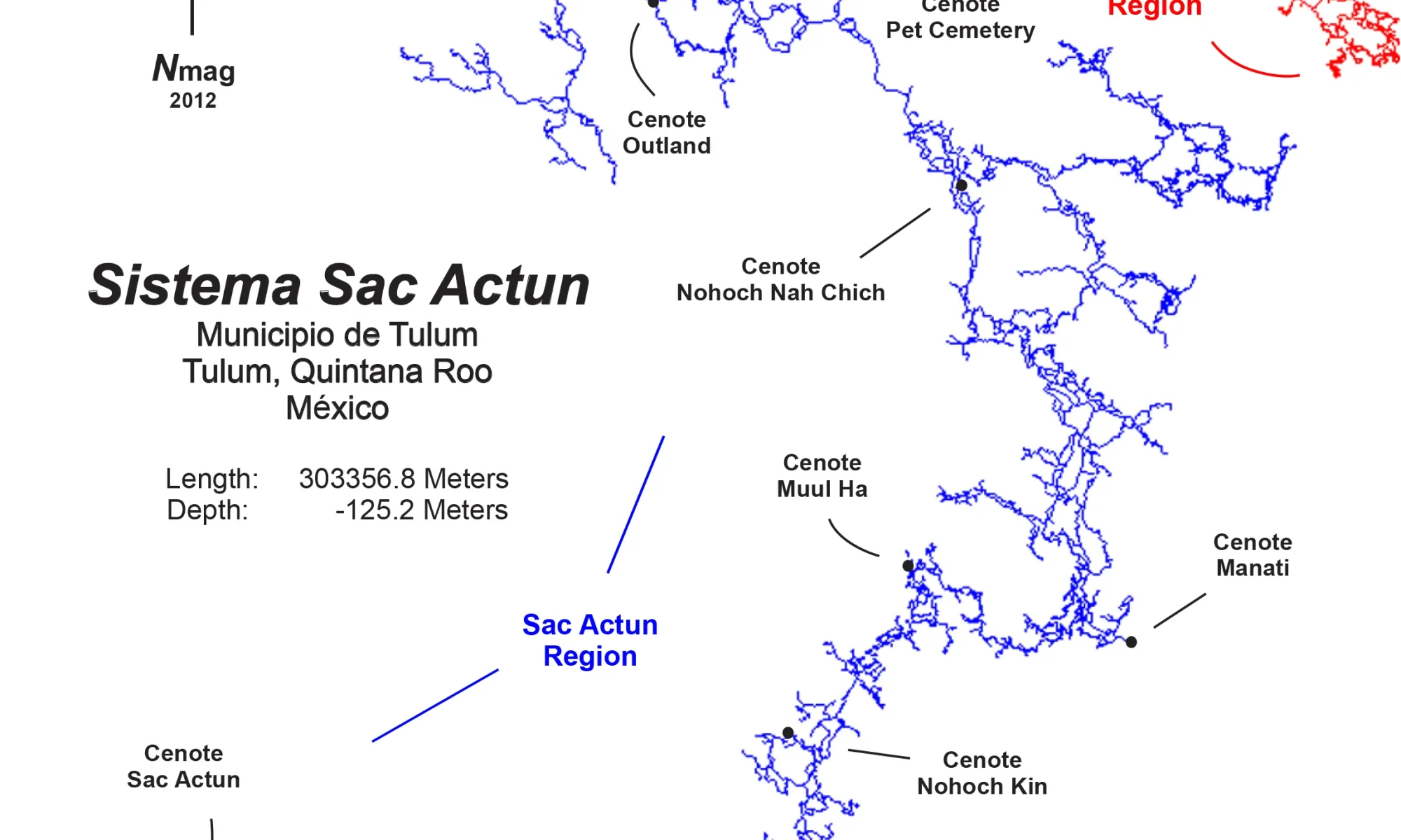
Nicte Ha Cenote is part of the Dos Ojos cave system of the same name. Connected system Sistema Sac Actun-Nohoch-Dos Ojos today is the world’s second-largest underwater cave system, 376,7 km (234 miles) of underwater lines, with a maximum depth of 119.18 mts (391 ft). Dos Ojos section is an anchialine cave system connecting to naturally intruding marine water and tidal influence in the cenotes. This cave system’s coastal discharge point(s) has not yet been humanly explored through to the ocean. Large volumes of groundwater were demonstrated by dye tracing to flow towards Caleta Xel-Ha, a nearby coastal bedrock lagoon.
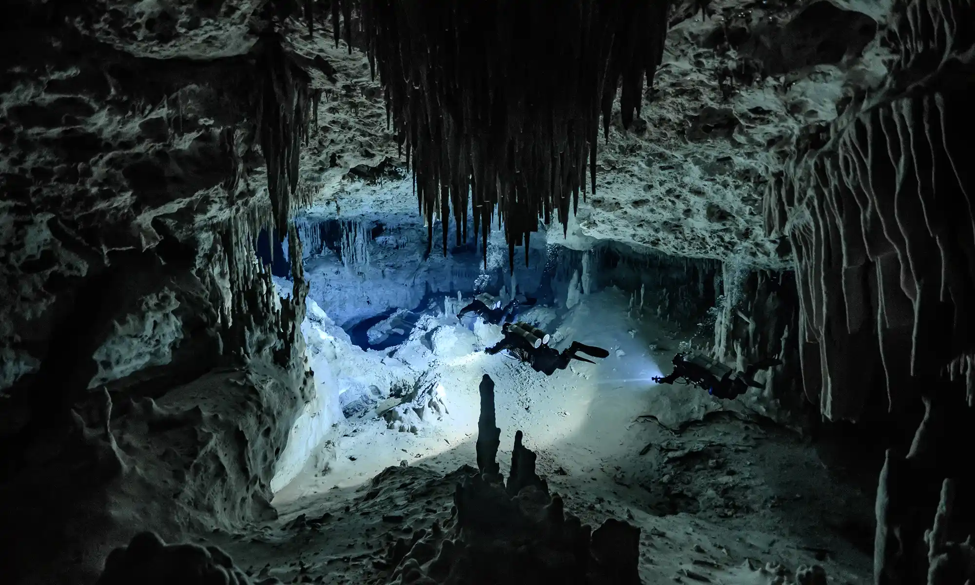
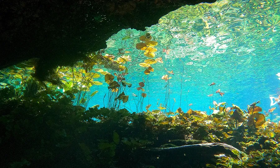
Known for its shallow dives, Nicte HaCenote offers cave divers plenty of time to enjoy the beautifully decorated system.
Nicte Ha Cavern line map
A cavern line is available for recreational divers to enjoy beautiful speleothems around the cenote entrance in the cavern zone.
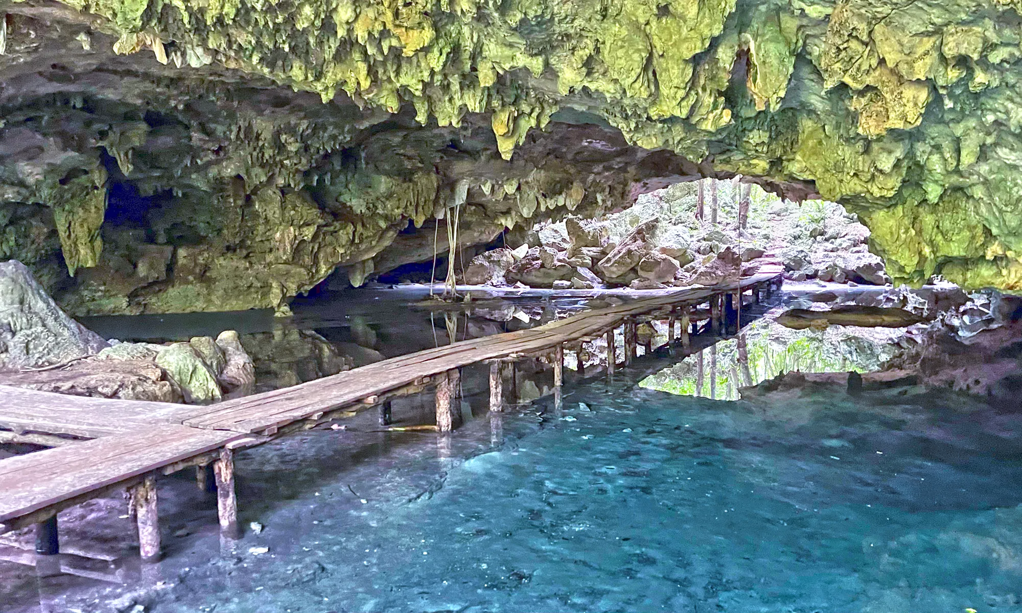
Nicte Ha Cenote underwater view
The owners remodeled the cenote entrance in 2013. They removed the old deck and palapa, enlarged the cenote’s open water area, and installed safe, easy-to-enter stone steps. Afterward, it was offered for swimmers and snorkelers to enjoy.
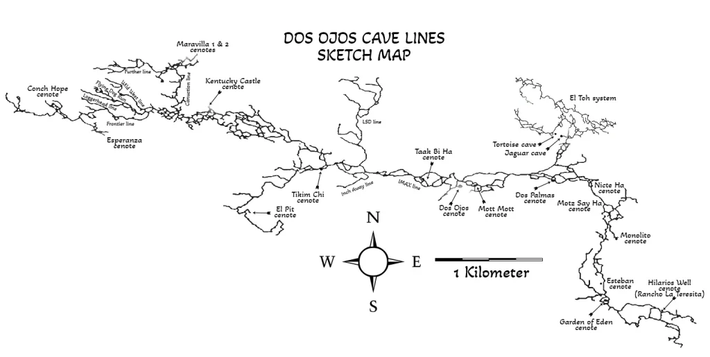
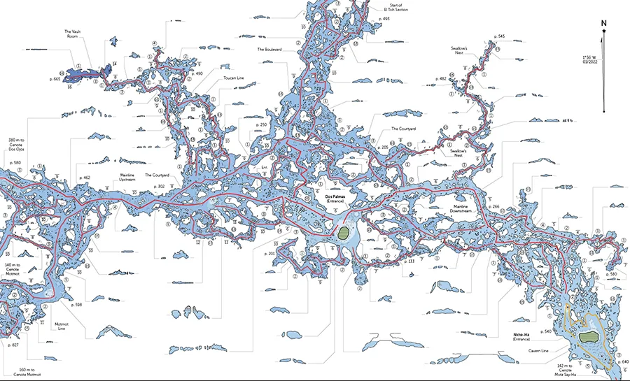
Dos Palmas, Mott Mott, and Nicte Ha Cenotes cave lines map
Upstream and Downstream lines
Cave divers can explore two permanent cave lines from the Nicte Ha Cenote cavern line. Accordingly, an upstream line toward Dos Palmas on the North and a downstream line toward Motz Say Ha and Monolito cenotes on the South. Besides that, there is one more short sidemount passage near the upstream main line.
The Nicte HaCenote cave lines suit beginners who are Intro to Cave (GUE Cave 1) divers who want to grow their experience before continuing to the Full Cave (GUE Cave 2) pass. Undoubtedly, you should install the main reel from the open water area to comply with Intro to Cave (GUE Cave 1) rules.
Nicte Ha Cenote location map
The first explorers were Chuck Stevens and Robbie Osman. Additional explorers include Steve Gerrard, Hilario Hiler, Dan Lins, Buddy Quattlebaum, Gary, and Key Walten. It was recently explored and resurveyed by Zack Bloom, Alex Fraser, Rory O’Keefe, Alessandro Reato, Severan Regehr, and Nicholas White.
Dos Palmas Cenote is one of the most stunning cenotes in the Dos Ojos cave system. The entrance to this famous cenote is located approximately 48 km south of Playa del Carmen. A 2.5 km dirt road leads from the highway to the cenote and parking.
The name “Dos Palmas” means “two palm trees”. It originated for the two palmas growing near cenote entrance. Few years ago one plam tree was died.
Dos Palmas Cenote is part of the Dos Ojos cave system of the same name. Connected system Sistema Sac Actun-Nohoch-Dos Ojos today is the world’s second-largest underwater cave system, 376,7 km (234 miles) of underwater lines, with a maximum depth of 119.18 mts (391 ft). Dos Ojos section is an anchialine cave system connecting to naturally intruding marine water and tidal influence in the cenotes. This cave system’s coastal discharge point(s) has not yet been humanly explored through to the ocean. Large volumes of groundwater were demonstrated by dye tracing to flow towards Caleta Xel-Ha, a nearby coastal bedrock lagoon.
Known for its shallow dives, Dos Palmas offers cave divers plenty of time to enjoy the beautifully decorated system. Four permanent lines can be explored directly from the Dos Palmas entrance platform. The most visited are the upstream and downstream lines. Dos Palmas cave lines suit beginners Intro to Cave (GUE Cave 1) divers who want to grow their experience before continuing to the Full Cave (GUE Cave 2) pass.
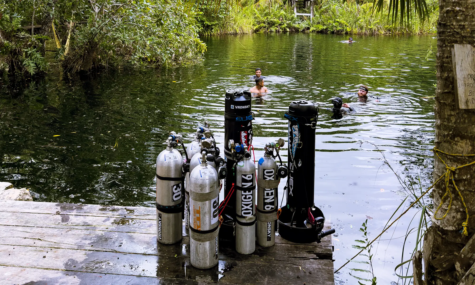
For your convenience, an equipment table is available where you can park next to the wood deck in the cenote. Walk down a flight of seventeen steps. There is a wooden deck platform with steps provided. You’ll also find bathroom facilities located behind the restaurant.
Dos Palmas, Mott Mott, and Nicte Ha Cenotes cave lines map
Upstream and Downstream lines
The maximum depth of this cenote area is 34 ft (10.4 m). It is a 3,500 ft (1,067 m) swim upstream (against flow) to Cenote Dos Ojos or a twenty-eight-minute swim downstream to Cenote Nicte Ha (High Voltage).
Dos Palmas Cenote location map
The first explorers were Steve Gerrard, Mark Grant, George Irvine, and Bill Mee in September 1992. Other explorers were Gary Walten, and others were unknown.
“This cave system is currently listed slightly over 273,294 ft (83,300 m) and has over thirty cenotes within its system as of June 2015. First discovered and explored in 1986 by Jim Coke and Johanna DeGroot, the only way they accessed it was by using a 1954 four-wheel Willis jeep that finally died in 1988. Dos Ojos (means“two eyes” in Spanish) lay dormant until 1992. It was the vision of a newcomer, Buddy Quattlebaum, who recognized the potential of this cave system that lay underneath the property of the Ejido Jacinto Pat.
But at the time, an outdated form of Mexican landownership system, the ejido, was in place, and so, Ejido Jacinto Pat was communaly owned by over 180 Mayan families spread over 8,400 hectares of land. Each family owns and works their particular parcel of land. There are several sections that consisted of general-use land governed by the ejido. Quattlebaum and a business partner, Marco Rotzinger, who together owned a dive business, recognized the potential of Cenotes Dos Ojos east and west to be a great place for snorkeling and cavern tours that will attract tourists and will economically benefit the ejido. The ejido agreed to allow a bulldozed trail be improved for vehicle access. This action opened the door for renewed cave exploration. It took off from there, not from an organized expedition format, simply individuals or small groups of individuals adding line here, pushing line there. Slowly but steadily, the cave grew in pieces and chunks. In one four-month span in 1994, Dos Ojos became bigger than Nohoch Nah Chich by 12,000 ft (3,636 m). But Nohoch kept staying ahead with its annual expeditions. At first, no one realized that both cave systems’ passages were found to be gradually becoming closer to each other. Though Dos Ojos never was organized as an expedition, the size, finances, and the logistics were slowly eroding the level of interest of the individuals making contributions to the exploration. Finally, publicity in a technical diving magazine portrayed the two cave systems as competing against each other. To rekindle the interest and trying to create publicity for Dos Ojos and the Ejido Jacinto Pat, a formal, organized expedition was formed during the first six months of 1996 with a two-week grand finale. The directors for the project were the author, Jill Heinerth, and Buddy Quattlebaum. This grand finale involved sixty cave divers and support personnel. It resulted in a total of 71,772 ft (21,749 m) of surveyed passages, including 46,827 ft (14,190 m) of passages, during the two-week grand finale. The expedition was considered a big success with no incidents or mishaps, remarkable for sixty cave divers participating and the challenging logistics that it entailed. Unfortunately, many divers/explorers believed negative publicity by some members of the diving journalistic press depicted the expedition more as a threat than an effort to see a cave grow in size. That image seemed to splinter the cohesive bond of the explorers, and the interest level quickly dropped to nothing on continuing the exploration. Today, Sistema Dos Ojos is opened to any qualified cave diver to explore. All that is asked is submit your survey data to the Ejido Jacinto Pat and the QRSS.
In 1991, it was Hilario Hiler of Akumal, who really cooked up the idea of diving a new cenote he found, which had in it two palm trees, and so he named it Dos Palmas. It was halfway toward Dos Ojos, near the bulldozed trail that now was becoming more useable through the hard work of many members of the Ejido Jacinto Pat. Hiler knew I had organized earlier mini expeditions for cave divers, exploring new cave systems, and that I was thirsty for a new hole to jump in. This Dos Palmas was it!
Still living in Florida, I was staying at Villas DeRosa with my typical week-long trips for cave divers, something I had started back in October of 1986. This group and I were there to explore and not tour. Timing was everything, and this was no exception. In my group were Mike Cameron of Toledo, Ohio; Mark Grant of San Jose, California; and Jim Mellon of Kansas City, Missouri. Also there for that week were Bill Mee and George Irving III of Boca Raton, Florida, who had hired Hilario for the week to find and explore new cenotes. We loaded (should say overloaded) up a DeRosa Dodge van of character with twelve sets of double 80 ft3 tanks. We somehow miraculously got the van all the way to the new power lines and then with hired sherpas to haul all the equipment the remaining 984 ft (300 m) to the cenote. The Mayans built a sturdy ladder, and we got everything down into the cenote. We had two days left in our week. We were originally began that week exploring a cenote on Don Camilo’s land near Cenote Toucha Ha but that proved to be a dead end.
Dos Ojos system cave lines map
Note: Today Cenote Dos Palmas is privately owned by the Mariano Mazon Can family. They charge one hundred pesos to dive this cenote. The entire cenote basin has been laid out with flat stone and a set of good steps have been put in place for easy entry or exit from the cenote. Very clean, nice bathroom facilities are available. One of the landmark palm trees had died several years ago.
At Cenote Dos Palmas, we successfully pushed our exploration upstream over 1800 ft (548.6 m) and downstream at least 1,200 ft. Little did we know that the River Ride path had begun. At the same time, Buddy Quattlebaum was pushing to another cenote upstream that Hilario had named Cenote High Voltage as it was located right next door to the power lines and a huge tower. He successfully connected with our downstream line that Jim Mellon and I had installed. Wow! Two connects and more beautiful cave for cave divers to dive and sightsee.
The spring of 1992, I returned with another group of cave divers. Buddy was over excited to push a downstream lead he found from the east Dos Ojos cenote, so we agreed to do it together with my group. There with me that time was Steve and Marianne Gamble of Gainesville, Florida, and Mike Cameron again. We decided on a day of the week, Wednesday, loaded up the now famous Buddy mobile and hauled ourselves and the gear to Cenote Dos Ojos. Our theory was simple: connect downstream Dos Ojos to Dos Palmas. Buddy was convinced because of the strong flow of water and the direction it was going that this connection was possible. Well, if you don’t go, you won’t know as I like to say! Off we went with me running the mambo exploration reel, Buddy doing the sniffing, and with everyone following for the fun. This passage was very interesting. It was very obvious that as the cave was once dry; it had water flowing through it, eroding away, a gully giving the obvious appearance of a cave on top of another cave. As the guide reel spun off line as fast as we could swim—gosh, I love that scenario—we pushe this downstream lead. We were about 1,200 ft (367 m) downstream and presto! There was another guideline. Connecting our guideline onto this one. We followed this guideline downstream. We swam 200 ft (61 m), and there was my original arrow marker. This confirmed we were at the point I had ended my original exploration dive months before with Jim Mellon, swimming upstream from Cenote Dos Palmas. Knowing exactly where I was and with everyone having plenty of air, we continued onward to Cenote Dos Palmas. Twenty minutes later, we arrived. What fun! Thus, on this one dive, we made the connection that was over 3,500 ft (1,067 m) in distance and officially blessed it by swimming the traverse. All within safe air rules, no deeper than 34 ft (10.4m) and an average of 22 ft (6.7 m). It does not get any better.
Two months later, Chuck Stevens of X’cacel and Robbie Osman of Oakland, California, pushed the downstream line of Cenote High Voltage and discovered another opening that they named Tapir’s End (Cenote Motz Say Ha) because of a dead wild pig that had fallen in. This cenote’s configuration made it impossible for a two- or four-legged creature to climb out. (Today, there is a wooden platform with steps to enter or exit.) A few weeks later, I returned to the Riviera Maya (August 1992) with my fourth tour cave diving group of that year. On my team were Bob Griffith, Rich Chapski, and Hank Whittenberg, Boston, Massachussetts, and Tim Brewton of Tallahassee, Florida. We jump into Cenote High Voltage with visions of pushing this cave downstream beyond Tapir’s End. That we did. But after 1,700 ft (518 m), it became too small and low for five cave divers to explore. (It as later pushed successfully by Chuck Stevens and Dan Lins.) But on that dive, we did find the official exit for the River Ride with a cenote that Buddy later named Monolito because of a huge rock leaning against the cave opening.
What was created as if a patch quilt was a continuous guideline from the Sistema Dos Ojos east to Cenote Dos Palmas to Cenote High Voltage (Nicte-Ha) to Cenote Tapir’s End to Cenote Monolito. Average swim time is usually 95 to 105 minutes of underwater bottom time. Maximum depth is 34 ft (10.4 m) with an average of 22 ft (6.7 m). You can easily reach each opening within a third of your existing air supply. The flow makes the trip relaxing with little effort. One word of caution, once you start at Dos Ojos, it’s better to commit to going through and not turning around because of the water flow, which we all think is some of the strongest for our area but certainly nothing compared to the high-flow springs of Florida. In addition, this cave is very pretty. The typical decorations, speleothems, and the wizardry of nature at work when the cave was dry fifteen thousand years earlier. A spectacular wonderland! During the past twenty-two years, I say more than four thousand cave divers dived this great traverse cave dive. A must dive for every cave diver who visits the Riviera Maya!”
Excerpt From The Cenotes of the Riviera Maya 2016 STEVE PENN GERRARD
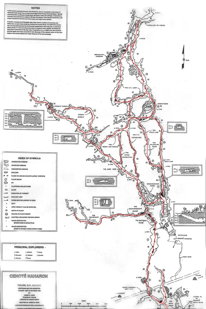
Cenote Naharon (Cristall) is considered one of the most outstanding because of the tannic-stained walls and decorations above the 60-foot (18.3-meter) halocline.
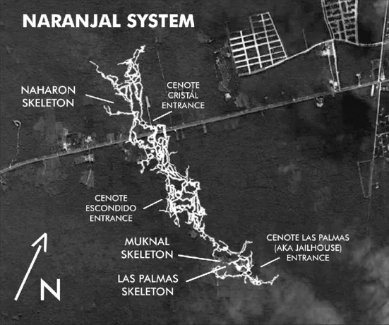
Historically, the Naharon (Cristall) Cenote, the Mayan Blue (Escondido) Cenote, and the Jailhouse Cenote were part of the Naranjal Cave system. On March 28, 2011, Steve Bogearts of Playa del Carmen connected Sistema Naranjal to Sistema Ox Bel Ha. Support cave diver Bil Philips of Tulum assisted with logistics.
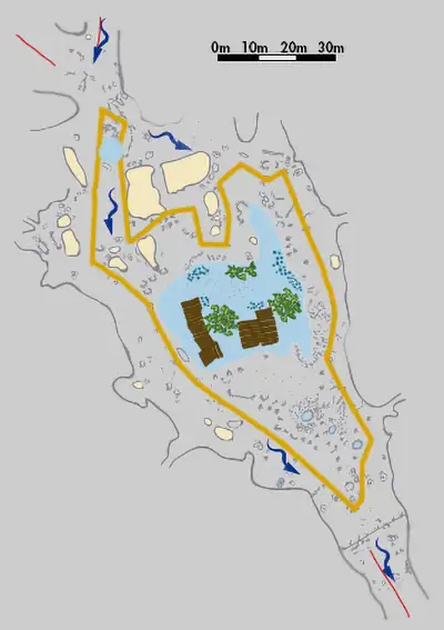
Naranjal Cave general map
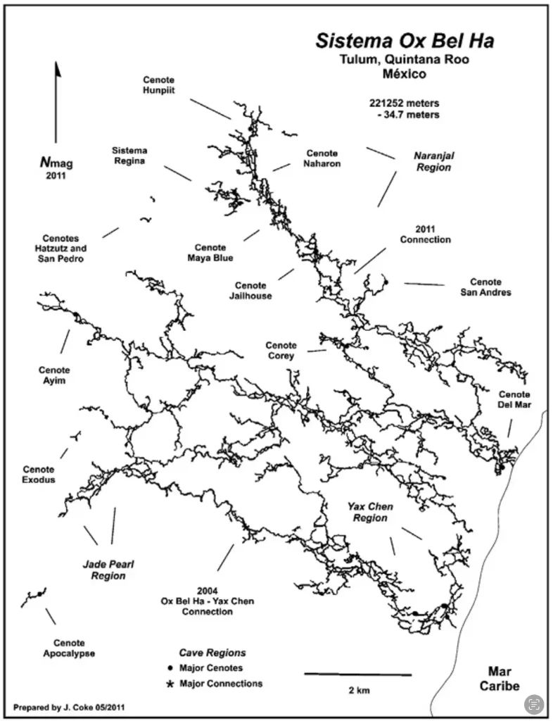
Nestled south of Tulum and near the captivating Sian Ka’an Biosphere Reserve, the Ox Bel Ha cave system unveiled its mysteries in 1996 when a team of cave divers embarked on its discovery and exploration.
Ox Bel Ha Cave System from January 2023 (thanks to CINDAQ team efforts) becomes again the World’s Longest Underwater Cave. It boasts an impressive length of 496.8 kilometers (308.6 mi), securing its status as the world’s longest underwater cave system. As of the end of 2023, the cave system encompassed 160+ cenotes. The most notable ones are cenote Jailhouse, cenote Naharon, cenote Escondido (Mayan Blue). According to the latest CINDAQ annual report, the system includes 56674 survey stations, 615 sections, more than 2500 jumps, 1500+ T intersections, and 7683 cave line markers.
Ox Bel Ha Cave System map
Ox Bel Ha general map
The Yucatan Peninsula’s distinctive geological history, a testament to the Earth’s transformative power over millions of years, has given rise to a sprawling labyrinth of underground passages and cenotes. This unique geological formation, a gift to cave divers and geology enthusiasts, has established the Ox Bel Ha cave system as a paradise to explore and admire.
Cenote Naharon (Cristall)
Tannic acid intrudes into the aquifer from a huge swamp area 8 km further west into the jungle. Within geological time (thousands of years), the tannic acid stains the calcium carbonate into a dark brown. Because everything is so dark, the cave divers’ light is absorbed. The few saltwater areas are not affected, as the calcium carbonate is bleached by the saltwater.
It has decent snorkeling spots and is a great place to swim and enjoy the cenote atmosphere.
There are upstream and downstream passages. One other cenote is upstream.
Upstream and downstream areas
When you dive into this cave, you will find yourself in Guillermo del Toro’s film based on Tolien’s story “The Hobbit: or There and Back Again”. You will feel like you are going into the depths of the Lonely Mountain to the lair of Smaug, Middle-earth’s last “great” dragon.
The best dives are the main line to Chac’s Room and beyond, which involves one jump. To get to the Deconocido Dome line, swim to the main line, take the first jump to the left of 8 ft (2.4 m), and follow that line 2,100 ft (637 m) upstream to the Double Domes.
The Southwestern Sacbe passage involves two jumps. Go to the permanent main line, take the first jump to the left, follow that line for 200 ft (60.1 m), and jump down a steep slope for 65 ft (19.8 m) to this offshoot line. One more jump left will bring you to traverse to Mayan Blue Cenote (to tunnel A) through The Southern Sacbe passage. Follow the line to the South, take T-left, and arrive at tunnel A of Mayan Blue Cenote.
The first explorer was Jim Coke in 1985. In 2003, Steve Gerrard and Sergio Granucci added 1400 ft of the line using DPV past Chac’s Room. Other explorers during the late 1980s were Steve Gerrard, Mike Madden, and Parker Turner. Other explorers have pushed the lines beyond what is on the map, but they are unknown.
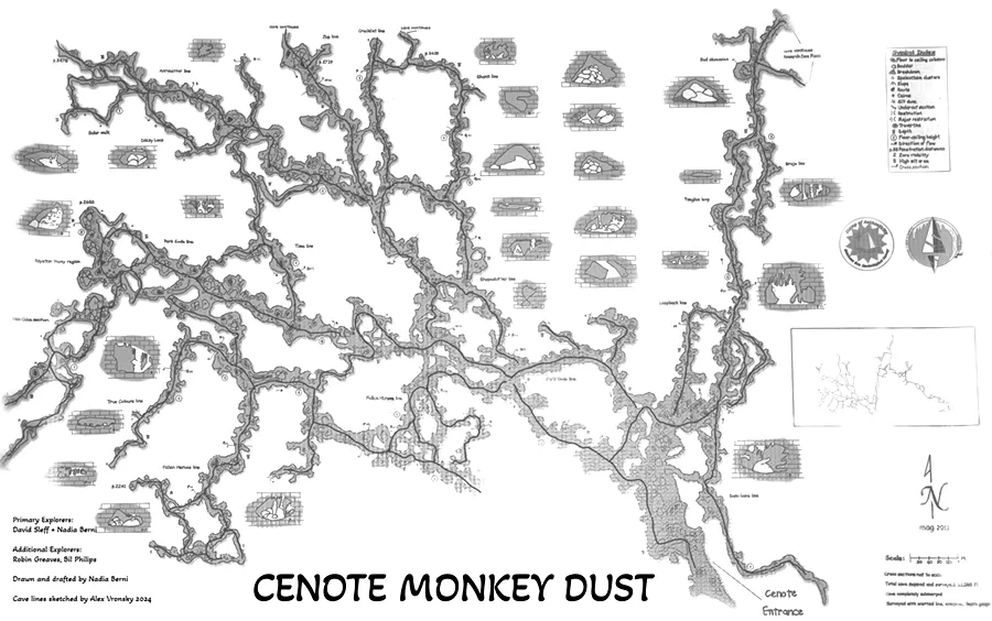
Robbie Schmittner considers the Monkey Dust Cenote (Dos Pisos) cave system one of the most beautiful in the Riviera Maya.
Monkey Dust is one of five cenotes in the Dos Pisos cave system. This unique marvel, spanning a linear distance of 46,509 ft (14,176 m) and reaching a maximum depth of 80 ft (24.4 m), is home to five distinct cenotes: Balam, Dos Pisos, Dos Pisos Norte, this cenote, and Cenote Zooz.
The permanent line is a bit left from the wooden platform and immediately guides you through the series of impressive chambers. The first T-intersection right brings you toward the Dos Pisos (next T left), while the left turn opens a whole set of the beauty of the this cenote cave area.
No facilities are available on site.
Monkey Dust Cenote cave lines map
cave lines map
Monkey Dust Cenote location map
Gunnar Wagner and Robbie Schmittner were the first pioneers to explore this magnificent cave system. They were followed by a group of intrepid explorers, including Nadia Bernie, Pat Cronin, Fred Devos, Phil Dotchen, Martyn Farr, Rob Greaves, Dig Hastilow, Steve March, and David Sieff.
