Cenote Nai Tucha is part of the K’oox Baal cave system (including the Tux Kapaxa system).
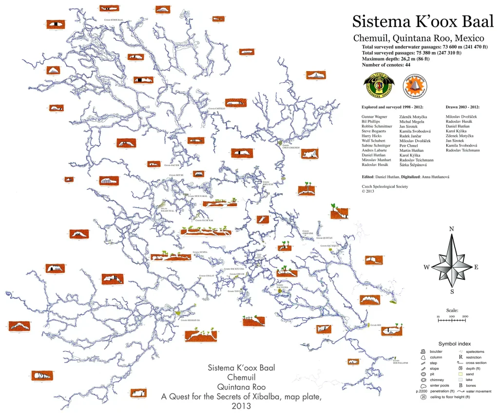
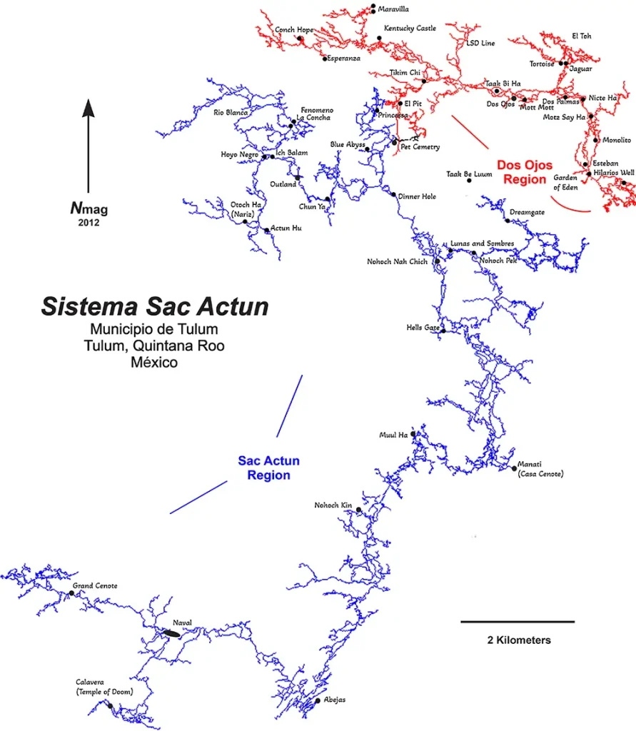
Between 2006 and 2011, cave divers explored more than 30 km of new cave passages in the Tux Kapaxa system. On December 9, 2011, the two cave systems merged and became known as K’oox Baal. Already boasting an impressive total cave line length of 75,140 meters, it was subsequently extended to 102,901 meters and is now proudly considered the fourth-longest underwater cave system in the world.
Historic Connection: “Mother of All Cenotes” Linked to K’oox Baal System
On June 22, 2025, Phillip Lehman, Patrick Widmann, Rosso Rivera, and Robbie Schmittner successfully connected the “Mother of All Cenotes” to the K’oox Baal cave system. This achievement followed the discovery of a navigable passage between the two systems, which lie approximately 1.5 kilometers apart.
To bridge the gap, the team laid over 8 kilometers of guideline, establishing a permanent connection between the cave networks. The exploratory dive lasted 425 minutes and was conducted using Seacraft scooters, mNemo mapping tools, and Sidewinder rebreathers, enabling the team to navigate, map, and document the newly accessed sections with precision.
With this connection, the total surveyed length of the K’oox Baal system now reaches 123 kilometers, marking a significant milestone in the exploration of underwater cave systems in the region.
By the way, the first (Ox Bel Ha) and second (Sac Actun-Nohoch-Dos Ojos) underwater cave systems in the world are also located here on the Rivera Maya and we can dive them as well
Establishing this connection is the culmination of years of effort by cave divers worldwide. Researchers have conducted hundreds of dives in the region’s caves and spent thousands of hours underwater. They spent hundreds of more hours exploring and navigating the treacherous jungle. They transported and maintained diving equipment, drove cars, and oversaw their endless repairs.
Today, the K’oox Baal is the world’s longest cave system, whose entire surface, including contours and cave lines, has been fully mapped.
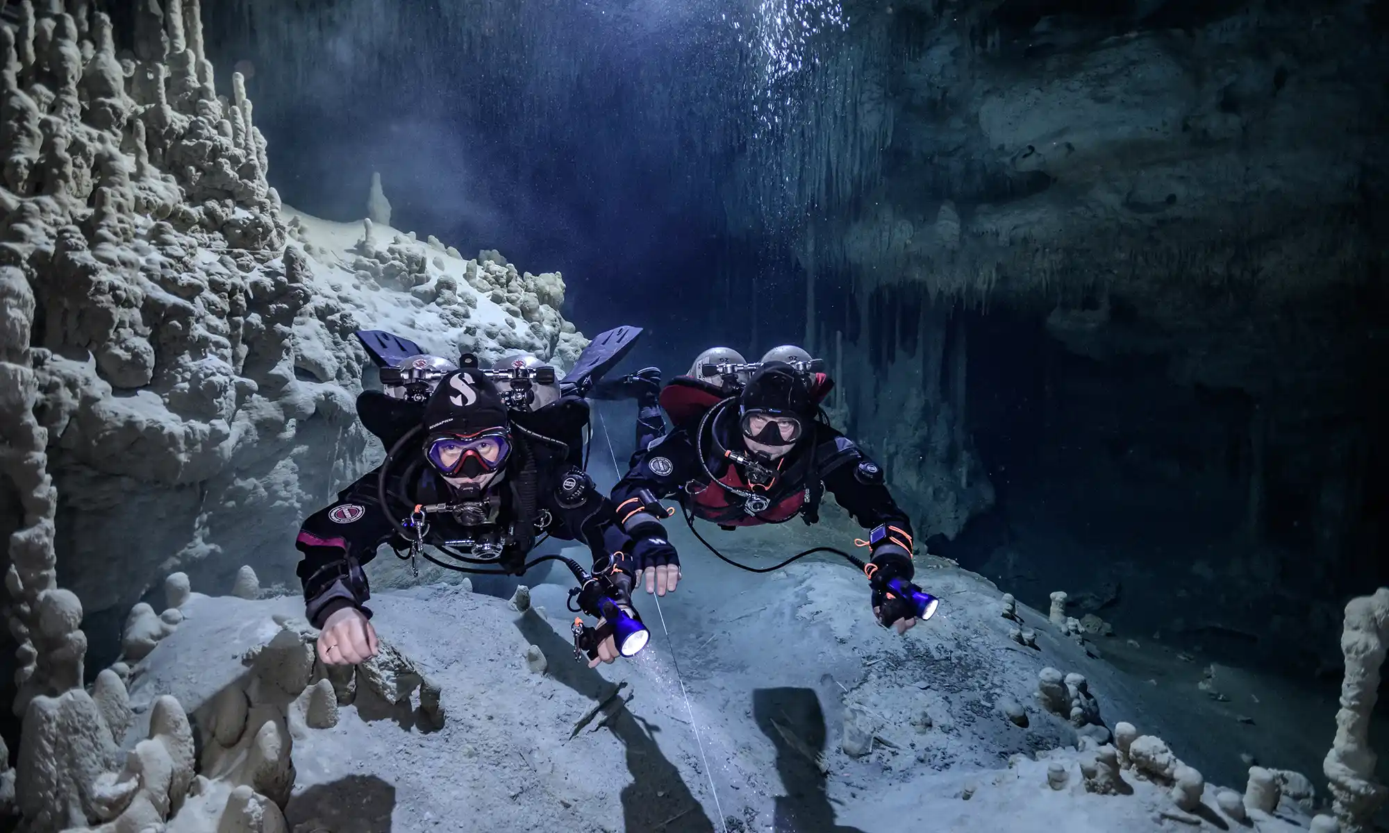
Cenote Nai Tucha (originally Tux Kapaxa, the Playground Cave) and Cenote Koi
The maximum depth is 48 ft (14.6 m).
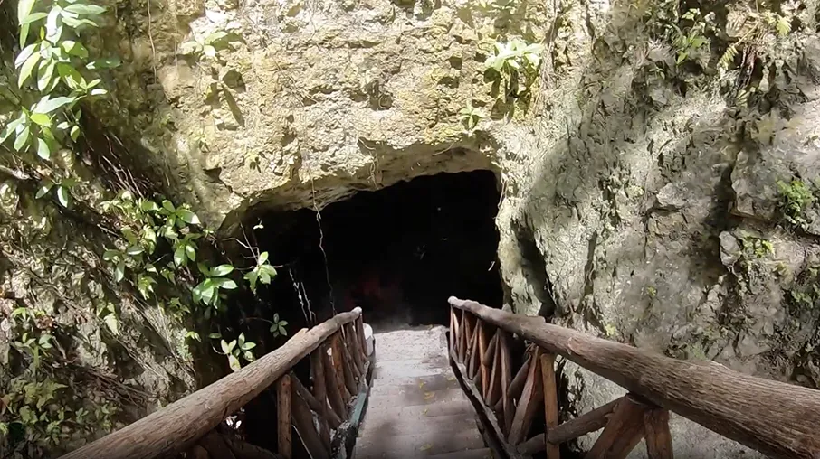
There are several openings to the surface, with one notable example being Cenote Nai Tucha. The main permanent guideline begins in the open water. Follow the main line, swimming for twenty minutes. Jump to your left, follow this 150 ft/ (45.7 m) shortcut, and jump back onto a main guideline. This section of the cave system has massive passageways and is highly decorated. Turn left and swim twelve minutes to an INAH-documented bone site.
Another great dive is to stay on the main line until you reach a permanent T intersection. Turn left and swim twenty minutes to the bone site. Swim straight; eight minutes later, you will reach an air dome with two shafts to the surface. From there, continue. You can swim straight to Cenote Koi or, at the far edge of the air dome on the permanent guideline, jump to your right 45 ft (13.7 m) for the more fabulous cave.
K’ooh Baal cave system map
Nai Tucha Cenote location map
The first explorers of the Sistema Tux Kapaxa side were Gunnar Wagner and Robbie Schmittner.
Bill Philips and Robbie Schmittner were the first explorers of the K’oox Baal System.
Other explorers were Steve Bogearts, Petr Chmel, Miloslav Dvoracek, Harry Hicks, Radoslav Husak, Daniel Hutnan, Martin Hutnan, Karol Kyska, Radek Jancar, Andres Labarthe, Miroslav Manhunt, Michal Megela, Theirry Minet, Zdenek Motycka, Bil Philips, Sabine Schnittger, Wulf Schubert, Jan Sirotek, Sarka Stepanova, Kamila Svobodova, and Radoslav Teichmann, Phillip Lehman, Patrick Widmann, Rosso Rivera, Max and Laura Tobey.
Cenote Coop One is part of the K’oox Baal cave system (including the Tux Kapaxa system).
Between 2006 and 2011, cave divers explored more than 30 km of new cave passages in the K’oox Baal system. On December 9, 2011, the two cave systems merged and became known as K’oox Baal. Already boasting an impressive total cave line length of 75,140 meters, it was subsequently extended to 102,901 meters and is now proudly considered the fourth-longest underwater cave system in the world.
Historic Connection: “Mother of All Cenotes” Linked to K’oox Baal System
On June 22, 2025, Phillip Lehman, Patrick Widmann, Rosso Rivera, and Robbie Schmittner successfully connected the “Mother of All Cenotes” to the K’oox Baal cave system. This achievement followed the discovery of a navigable passage between the two systems, which lie approximately 1.5 kilometers apart.
To bridge the gap, the team laid over 8 kilometers of guideline, establishing a permanent connection between the cave networks. The exploratory dive lasted 425 minutes and was conducted using Seacraft scooters, mNemo mapping tools, and Sidewinder rebreathers, enabling the team to navigate, map, and document the newly accessed sections with precision.
With this connection, the total surveyed length of the K’oox Baal system now reaches 123 kilometers, marking a significant milestone in the exploration of underwater cave systems in the region.
By the way, the first (Ox Bel Ha) and second (Sac Actun-Nohoch-Dos Ojos) underwater cave systems in the world are also located here on the Rivera Maya and we can dive them as well
Establishing this connection is the culmination of years of effort by cave divers worldwide. Researchers have conducted hundreds of dives in the region’s caves and spent thousands of hours underwater. They spent hundreds more hours exploring and navigating the treacherous jungle. They transported and maintained diving equipment, drove cars, and oversaw their endless repairs.
Today, the K’oox Baal is the world’s longest cave system, whose entire surface, including contours and cave lines, has been fully mapped.
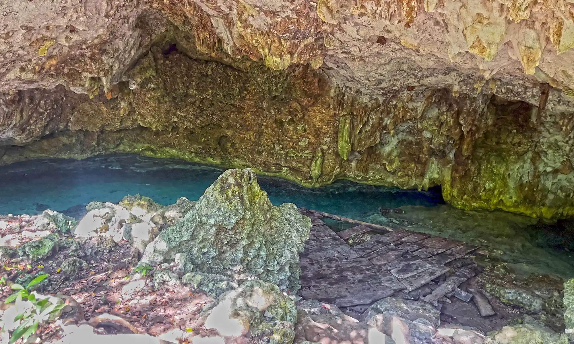
Cenote Coop One (Big Hole), a.k.a. Tam Hol in Maya
The maximum depth of the Coop One section of the cave system is 45 ft (13.7 m). You will find the permanent line on the far side from where you walk down a ramp and past the wooden deck with a ladder leading straight up to the surface.
K’oox Baal Cave system map
K’ooh Baal cave system map
Coop One Cenote location map
The first explorers of the Sistema Tux Kapaxa side were Gunnar Wagner and Robbie Schmittner.
Bill Philips and Robbie Schmittner were the first explorers of the K’oox Baal System.
Other explorers were Steve Bogearts, Petr Chmel, Miloslav Dvoracek, Harry Hicks, Radoslav Husak, Daniel Hutnan, Martin Hutnan, Karol Kyska, Radek Jancar, Andres Labarthe, Miroslav Manhunt, Michal Megela, Theirry Minet, Zdenek Motycka, Bil Philips, Sabine Schnittger, Wulf Schubert, Jan Sirotek, Sarka Stepanova, Kamila Svobodova, and Radoslav Teichmann, Phillip Lehman, Patrick Widmann, Rosso Rivera, Max and Laura Tobey.
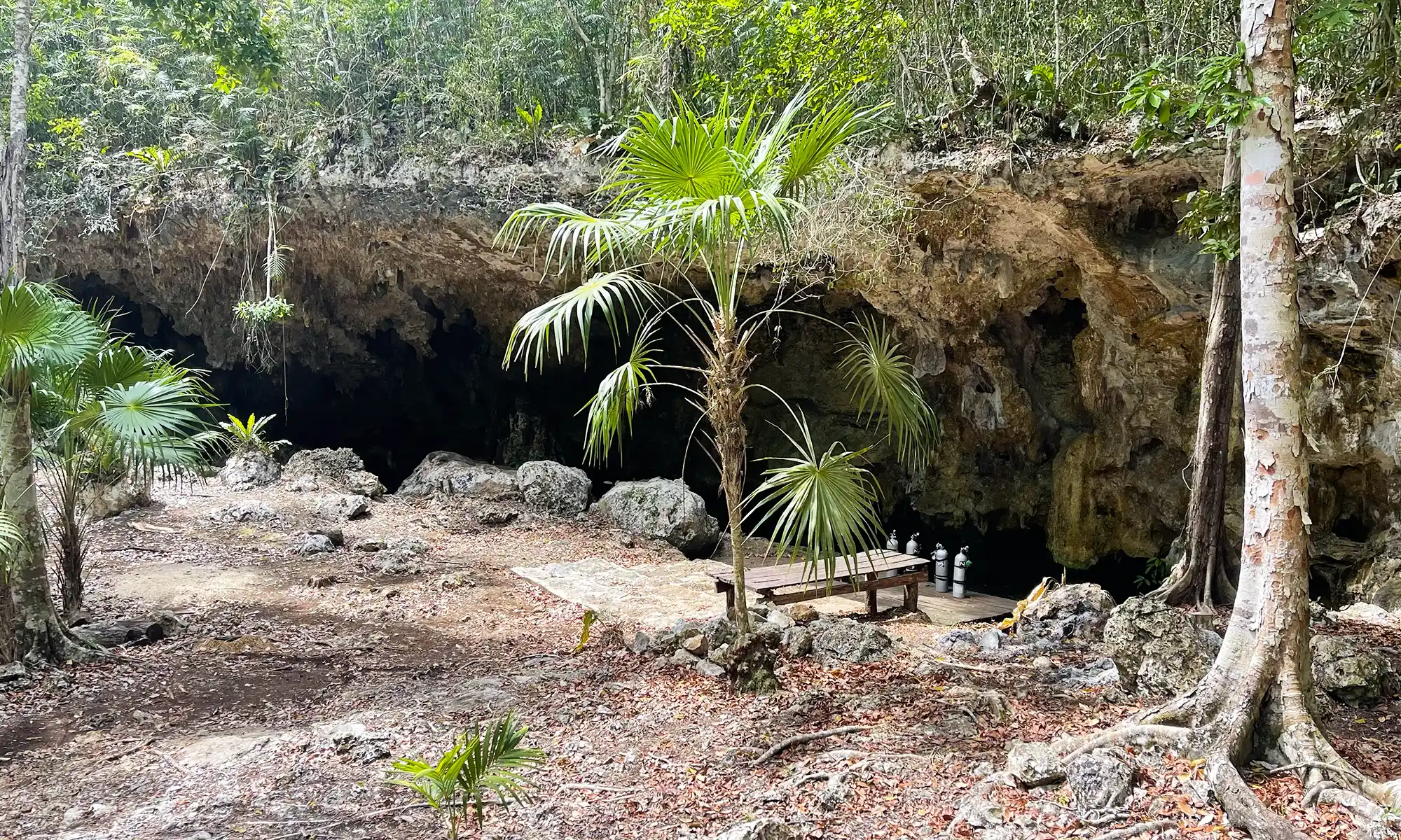
The Outland cenote is part of the huge underwater cave system Sac Actun—Dos Ojos—Nohoch Nah Chich.
Turning toward Outland Cenote into the jungle on the 54th kilometer from Playa del Carmen of the Cancun-Tulum federal road, you will find yourself on a country road. Following, the dusty, bumpy road leads deep into the jungle. It connects the entrances to a multitude of beautiful cenotes. Caracol, Chun Ya, Otoch Ha, Outland, La Concha, Fenomeno, etc.
Cenote Outland is part of the connected system Sac Actun-Nohoch-Dos Ojos. Moreover, it is the world’s second-largest underwater cave system, with 376,7 km (234 miles) of underwater lines. The maximum depth is 119.18 mts (391 ft). The Nohoch historical section is an anchialine cave system connecting to naturally intruding marine water and tidal influence in the cenotes. However, this cave system’s coastal discharge point(s) has not yet been explored into the ocean. Despite this, dye tracing to flow towards Caleta Xel-Ha, a nearby coastal bedrock lagoon, demonstrated large volumes of groundwater.
Sac Actun-Nohoch-Dos Ojos Cave lines with cenotes name General Map
The next world’s longest cave system, Ox Bel Ha, is very close — just a few kilometers south. So, perhaps shortly, a place will be discovered where these two cave systems connect. The combined cave system will be the largest underwater cave system in the world and the largest cave system in general, including dry caves.
Farther away in the forest, an 8km potholed dirt road leads to the Outland Cenote. The entrance is fenced and locked. Outland is a half-collapsed sinkhole with a huge Alamo tree extending its roots like the tentacles of a crawling octopus. The atmosphere of the jungle was overwhelming. Entry to the water was very shallow, over brown rocks. Outside the cave were tall leafy trees, and beautiful “motmot” birds flew by.
Sneaking through a gateway in the limestone, we immediately plummeted to a depth of 8m for the rest of the dive. Visibility is always clear. At the first T-junction, a few meters from the guideline’s beginning, we can turn left and right. The right part is quite more extensive. Soon after, you meander through various chambers of the Outland Cenote with columns, stalagmites, stalactites, and helictites hanging from the roof like darts.
The first explorers were Steve Penn and Mike Madden.
Connected to Sistema Aktun Hu by Alex Alverez, Franco Attolini, and Beto Navo in November 2007. Connected to the Nohoch area by Robbie Schmittner on January 30, 2011.
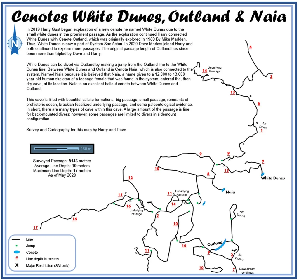
In 2019, Harry Gust began exploring a new cenote called White Dunes. As the exploration continued, Harry connected White Dunes with Cenote Outland. In 2020, Dave Marlow joined Harry, and both continued to explore more passages. Dave and Harry have more than tripled Outland’s original passage length.
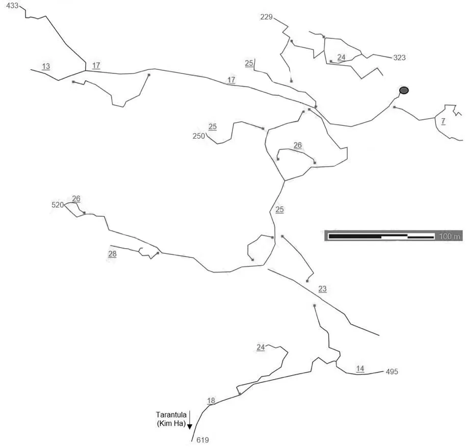
On the road to Valladolid from Tulum, several well-known cenotes are available for cave diving. One is Tortuga Cenote, the entrance to which is combined with the road to two more cenotes: Vaca Ha Cenote and Kim Ha Cenote.
The Tortuga cenote is located at the end of the private road. Approaching the cenote, you will see a small pool with convenient steps. The pond is about 6 meters in diameter in the jungle. Near the cenote, there is a parking lot for three cars. There are no amenities. You can get dressed and dive in.
The maximum depth of the Tortuga Cenote cave line is 28 meters, the average depth is 20 meters, and the length of the surveyed passages is 2488 meters. At a depth of 19 meters, there is a halocline between fresh and saltwater. The Tortuga Cenote cave line is connected to the neighboring Kim Ha Cenote cave line.
The permanent line of the cave begins at the surface, tied to a log. There is a freshwater zone of 1,200 ft (362 m) with various beautiful decorations. There are two T intersections in the freshwater zone. The first permanent intersection goes left and down into the saltwater zone. The second permanent intersection splits into two dead ends. The freshwater zone is known as the First Strike Run. The saltwater zone is named the Gateway. This cave system is an incredible example of water drainage, showing how the limestone is eroded through geological time.
There is an underwater connection from Tortuga Ha Cenote to Kim Ha Cenote in the South-East.
Our Kim Ha, Vaca Ha, and Tortuga Cenotes cave diving video
The first explorers were Ivan and Mary Cappelli, Randy Douglas, Sam Ferra, Steve Penn, Allen Jonushaitis, Cliff Keck, and Don Redinger. Other explorers are Jim Kitka, Daniel Riordan, and R. Weijski-Wol.
It was connected to Cenote Kim Ha during the summer of 2004.
While diving the Riviera Maya cenotes, you can witness the geological calendar. You will see spectacular formations formed during the last Ice Age and appreciate the archaeological discoveries through your mask. As visitors, cave and cavern divers learn to be safe and careful to observe and preserve this unique and beautiful cave environment.
The word “cenote” is derived from a Mayan term D’zonot and represents a subterranean cave that contains permanent water.
Types of underwater cenotes and caves
There are five categories of underwater caves:
Sea caves
Coral caves
Lava flow caves
Glacier caves
Solution caves
They share similarities in composition, general location, shapes, and tools of origin. Solution caves represent most of the caves found worldwide and makeup all the cenotes and underground cave systems along the eastern Yucatan Peninsula.
Limestone is a large grouping of similar minerals comprising calcium carbonate (CaCO3). The shallow tropical oceans help produce an abundance of these sediments called lime. Most of the lime derives from the calcium skeletons of marine animals and some types of algae. These sediments accumulate over geological time and form into layers. Time, pressure, and temperature solidify these sediments into rock material. The compacting, cement bonding and recrystallization of the lime sediments accomplish this metamorphosis.
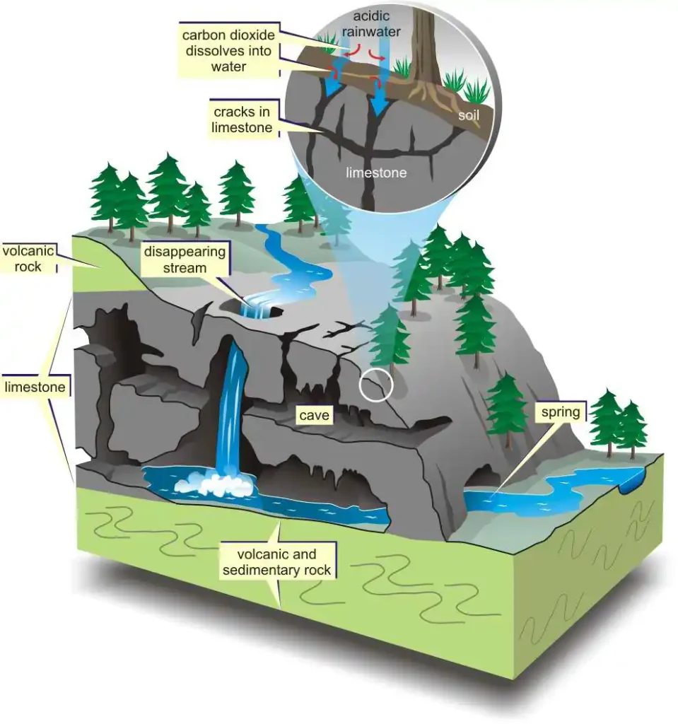
Dissolution is the breakdown and removal of rock formation caused by acids facilitated by freshwater circulation within the pores that comprise part of the rock’s volume.
Evolution of cenotes
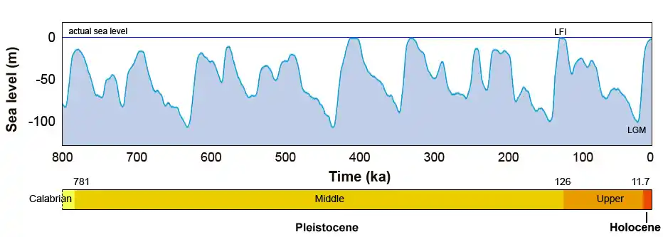
The tremendous presence of limestone collapses characterizes the landscape as the ideal karst terrain. A steady underground water movement through a vast passage network flows where it finds the least resistance. The volume of water drainage is so great that it cannot exist on the surface. The soft, porous limestone highly filters all water, causing it to flow underground.
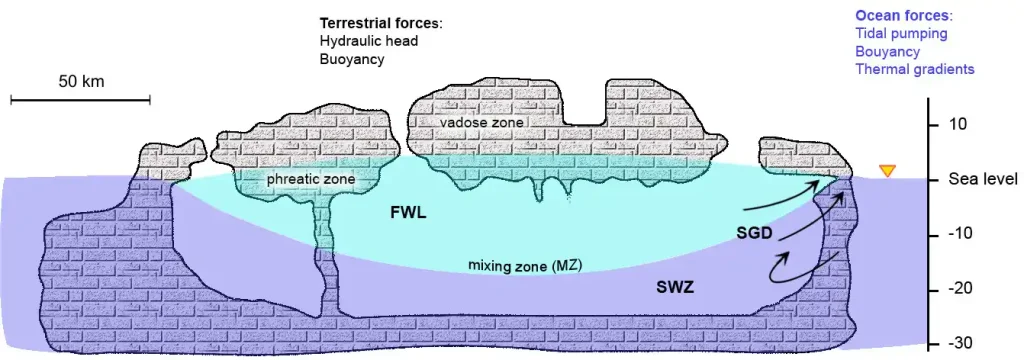
We know the evolution of cave passageways that form or exist below the water table as the phreatic zone. The water moves through the passageways (pores) vertically and horizontally from higher to lower pressure.
The vadose zone is any chamber, passage, or air space that forms above the aquifer. Many vadose passages and rooms exist in both the local cavern areas and cave systems. The Riviera Maya is a thick limestone with low relief and a high water table. The water table rose and fell during the last Ice Age, causing rapid cave development and creating the best surroundings for cave diving.
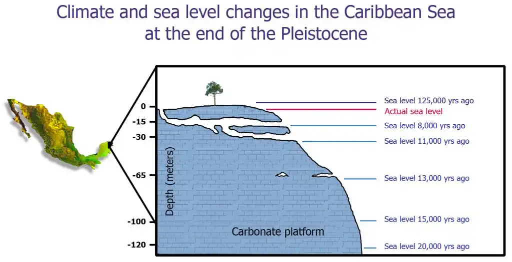
World ocean level simulation +10 meters / -130 meters
Any time a cave diver plans to explore a new cenote, it is important to understand the physical features and water flow. Cave openings provide information about water movement, the point of the compass, clarity, and general characteristics. Understanding these clues allows the cave diver to explore the potential cave system with the best results.
Cenotes can be any shape or size. They can appear as a pond, such as the Cenote Carwash; a tiny shaft, such as Cenote Mundo Escondido (Hidden World); a crack, hole, or lagoon. Any form of collapse can represent a cenote. Cenotes can also be mostly dry, with the jungle continuing to survive inside the basin and water flowing around the edges. Good examples include the Grand Cenote, Cenote Chac Mool, and Cenote Tajma Ha. Cenotes can also be filled with water.
Water in the cenotes
Distances from the normal land surface to the water can vary from a few feet up to thirty feet (ten meters). Consider the difference in distance at Cenote Naharon (Cristal), which drops only one foot, compared to Cenote Dos Ojos, which falls over twenty-five feet (7.6 meters) from top to bottom. The surface and topography of the land and the underground water table play important roles in the cenote formation.
Water that flows into the cenote is called the spring side or upstream area, also known as the outlet. Water that flows from the cenote back underground is known as the siphon side or downstream area.
Hazards exist when diving downstream because of the minimal water flow. Water in the cenote basin is called the pool. The water volume and flow will vary, but the water flow is minimal because most water drainage originates from a horizontal source and not depth. Cenotes close to the coast, such as Cenote Manati (Casa cenote), may be affected by water flow or reverse direction due to the tides. Water levels will fluctuate by 12 in or more in the Cenote El Eden between a high and low tide. In cave passages, you can view saltwater moving upstream while the freshwater continues to drain downstream.
These cenotes are known as anchialine pools, a term coined by Holthuis (1973) to denote “pools with no surface connection to the sea, containing salt or brackish water, which fluctuates with the tides.”
How Solution Cenotes and Caves Form
Several conditions are necessary to form solution caves. These items are:
host rock,
groundwater,
structural setting,
and time.
The host rock is the limestone found in the Yucatan. Between this bond of limestone cement and these granules are spaces called porosity. Add the rock material’s ability to transmit fluids, making the limestone permeable.
A constant flow of freshwater dissolves away the calcium carbonate. Fresh water is more acidic because it has higher dissolved carbon dioxide (CO2) and humic acids. Acidity allows the aggressive dissolution of calcium carbonate to break down the cement that bonds the original particles together. The naturally occurring mixture of CO2 and water creates carbonic acid (H2CO3).
Groundwater must continually flow with fresh, chemically unsaturated water, passing through the rock pores to flush the newly dissolved cement away from the particles. Freshwater flow is an important process in the formation of solution caves.
The structural setting is an integral process in the formation of caves. Most caves form when the cave passages are immersed in the freshwater flow of the aquifer so that the calcium carbonate glue is exposed to maximum decomposition and dissolution.
Time is the overall factor that forms caves. Thousands of years’ worth of constant reactions and water movement are necessary for cave development. This geological calendar allows the cave to evolve, shape itself, and form the decorations and characteristics it contains.
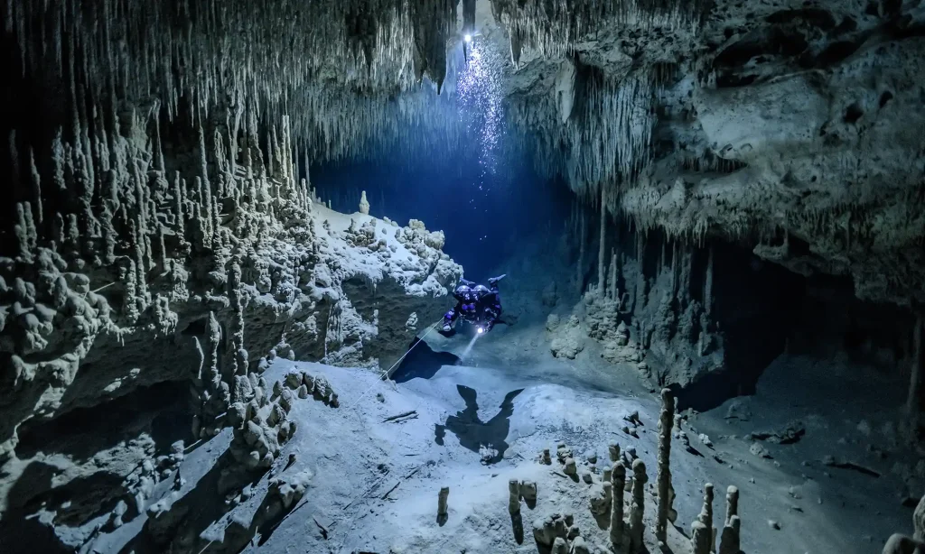
Speleothems
Picture yourself floating through some of the most decorated caves in the world. You only need to drive 2.5 km south of Akumal to a commercial dry cave called Aktun Chen, the wood cave. This cave adventure is very popular because it will dazzle your imagination and answer the most commonly asked questions: Why cavern dive, and what do you people see in caves? Aktun Chen is an archaeological gallery of cave formations produced by mineral deposits known as speleothems. The name is taken from the Greek spelling meaning “cave” and thema meaning “deposit.” Speleothems are mineral deposits that formed when the environmental conditions were just right. This occurrence in the cenotes took place during the last Ice Age.
Most speleothems are made up of crystallized calcium carbonate. The deposits can evolve into any shape or form. The most common and familiar speleothems are stalactites and stalagmites. When it rains, groundwater seeps through the porous limestone and into the cave, where carbon dioxide can be absorbed into the cave atmosphere. This outgassing of carbon dioxide from the groundwater makes calcium carbonate and precipitates calcite.
The first step in forming these beautiful cave features begins with soda straws. They are hollow, tubular calcite stalactites usually no bigger in diameter than the water droplet that formed them. If the water droplets can flow down outside the soda straw, they become thicker and form a stalactite.
Various speleothems
The following descriptions explain the various names of speleothems:
Draperies – calcium carbonate forming as layers or drapes from water droplets flowing down walls or ceilings.
Helictites are calcium carbonate that forms twisting, irregularly shaped branches or twig-like rods that extrude from the walls or ceiling. Water oozes through the central core of the formation, defying gravity. They can evolve into very odd designs and form in random directions.
Columns – form when stalactites and stalagmites join together.
Flowstone – a thin film of calcium carbonate from water flowing down a wall.
Dripstone – dripping water forming speleothems such as stalactites and stalagmites.
Rimstone dam – a calcium carbonate deposit that forms around a cave pool or tends to obstruct a cave stream
The appearance of underwater speleothems that form only in the air indicates that the underwater caves of the Riviera Maya were once dry and are now immersed by rising water levels.
Our unique expandable interactive map of Riviera Maya cave diving cenotes is available for Cave Certified divers
– Cenotes available for Open Water divers and Cave Certified divers
– Cenotes available for Cave Certified divers only
🗺️ Additional Way to Find Updated Cave Maps on Our Website
The most up-to-date Mexican cave maps are available directly in the top menu of this website under the section “MEXICAN CENOTES & CAVES.” There, you can explore interactive and downloadable maps organized by geographic area, for example: “PUERTO AVENTURAS CAVES AREA,” “CHEMUYIL CAVES AREA,” “DOS OJOS CAVE AREA,” and many more. Use this menu to quickly find the detailed maps and information for the specific cave systems and cenotes you are interested in across the Riviera Maya.

